

SHF BAND INSIGHT #5
Summary of Microwave Activity 2022 in the Mediterranean Area (EA - F - I)
During 2022, we have had good propagation in the microwave bands. Enjoying good tropospheric (Tropo; TR) conditions over the Mediterranean Sea. Also, plenty of opportunities for communications through storms (Rain Scatter; RS). Via Rain Scatter, apart from using SSB, which is sometimes complicated to understand, we had excellent results in the FM mode, even at long distances. The tropo also allowed many tests on DATV.
Hyper IQ0SS Expedition
In addition to the usual activity, in June, we thank the French Hyper Group microwave expedition to the island of Sardinia as IQ0SS.
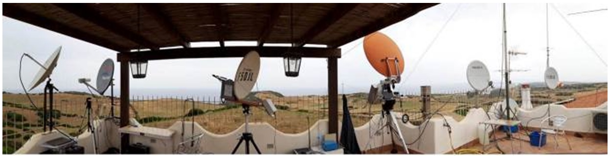
Figure 1. Installation of antennas of the IQ0SS expedition. (Photo: J-Paul F5AYE)
This group, since many years ago, has been stationing itself in different points of the Mediterranean Sea, animating with microwave communications. This activity on the microwave bands is called "La Grande Bleue." It was started in 1996 by Serge F1JSR, with Michel HB9AFO.
Last year in 2022, the French group was formed by F5DJL Jean Louis, F5BUU Jean Claude, F5AYE Jean Paul, F1BJD Jean Luc. They were operational from 50 MHz up to 24 GHz on CW/SSB. They were also QRV on terrestrial DATV and through the geostationary satellite QO-100. The uplink band was 13cm (2405 MHz) and downlink 3 cm (10.495 GHz). In DVB-S2 (S2QSPSK) and Symbol Rate 333 mode. The best terrestrial distances were achieved at 10 GHz. ODX over 10 GHz with Maurice F6DKW, with more than 1000 km followed by Daniel DL3IAE, with 950 km. See Figure 2.
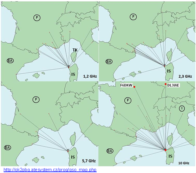
Figure 2. IQ0SS (GL:JN40CS) microwave dispatch activity
QO-100 Satellite
In the EA (Spain) area, the maximum activity in the 13 cm band is concentrated through the QO-100 geostationary satellite at 2400 MHz and above. Both in voice (SSB), CW and Digital modes, activating the narrowband transponder, and for DATV mode using the wideband transponder.
Tropospheric propagation (TR)
Since May in 2022, there have been good tropospheric openings caused by thermal inversion over the sea. In some case combined with the reflection over airplanes (AS), coinciding with the directions of the antennas, on their routes. The QSO maps have been made with the help of the web site: http://ok2pbq.atesystem.cz/prog/qso_map.php.
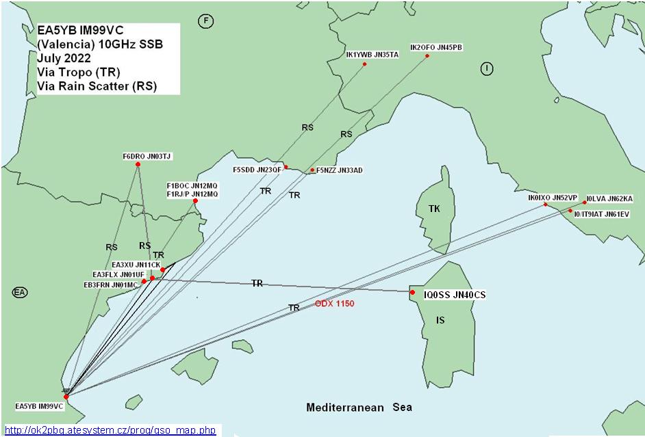
Figure 3. Activity map of EA5YB and EA3FLX on 10 GHz via RS and TR.
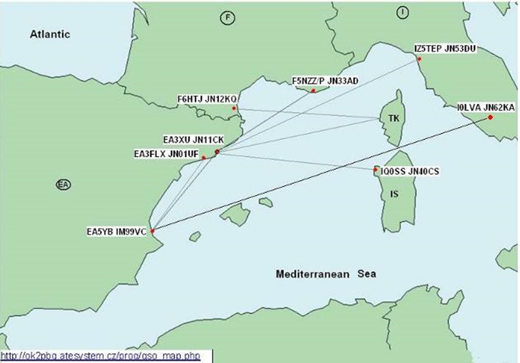
Figure 4. Joint activity map for EA5YB, EA3FLX and EA3XU on 5.7 GHz.
Propagation via Rain Scatter (RS)
Since June, in the afternoons, there have been propagation openings through the storms. We have had several opportunities with the south of France, from the EA3*1 and EA5*2 areas, over the Pyrenees mountains range above 3000 m of its summits, especially in the month of August, almost daily. See also the beacon reception maps of EA5YB in Valencia and EA3XU in Barcelona.
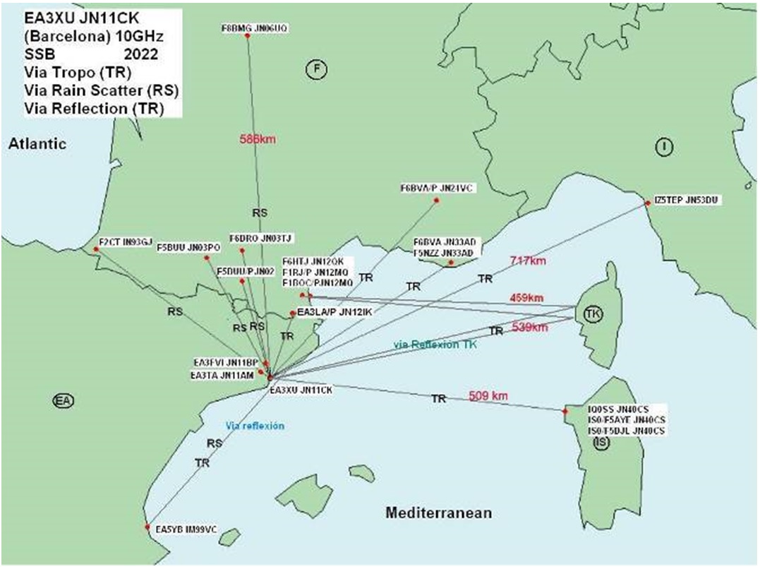
Figure 5. EA3XU activity map on 10 GHz via Tropo and Rain Scatter
Beacons via Tropospheric propagation (TR)
Special mention to the IQ5FI/B beacon of (GL:JN53SR) operating on 13, 6 and 3 cm, located 830 km from my QTH. It is a great indicator of Tropospheric propagation status. I have received the IQ5FI/B in the months of: February, May, June, July, August, and October 2022. Also, the 23 cm F1ZAK/B (GL:JN23MM) and (GL:TK5ZMV/B, JN41JS) 23 cm beacons on Corsica Island. See Figures 8 and 9.
Beacons via Rain Scatter (RS)
In my area of Barcelona (GL:JN11CK), I have received the French 10 GHz beacons: F5ZAE/B (GL:JN12LL), F5ZWZ/B (GL:JN23XE), F1ZIR/B (GL:JN24VC), F1ZCL/B (GL:JN33KQ), F5ZEP/B (GL:IN94QT). I have also received several controls from Vicente EA5YB in (GL:IM99VCV) from Valencia. See Figures 8 and 9.
The weather radar maps shown below help to detect RS possibilities and search for beacons by centering the antenna on the red areas of the map. In case of copying any beacon, the opening of Rain Scatter would be confirmed and contacts towards that particular direction could be attempted. The possibilities are dynamic and vary according to the progress of the storm conditions.
Radars meteo maps:
Spain: https://www.aemet.es/es/eltiempo/observacion/radar
Catalunya: https://es.meteocat.gencat.cat/radar
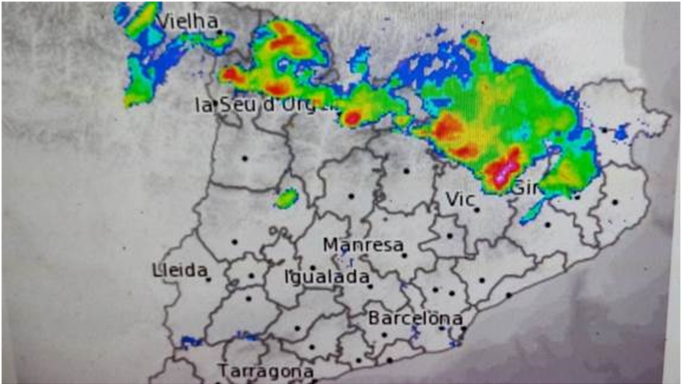
Figure 6. Weather radar maps
Meteocat.cat Radar. Example of the Radar. Area Catalonia. (https://es.meteocat.gencat.cat/radar)formations over the Pyrenees Mountain range used for microwave communications especially in the 3cm band (10368 MHz). Used modes SSB, FM and CW.
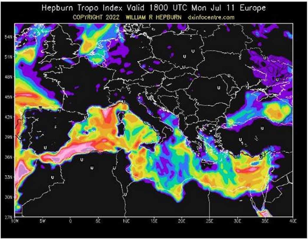
Figure 7. Tropo Mediterranean predictiónTropospheric forecast map Hepburn 18 July 2022.Europe.(https://www.dxinfocentre.com/tropo_eur.html)
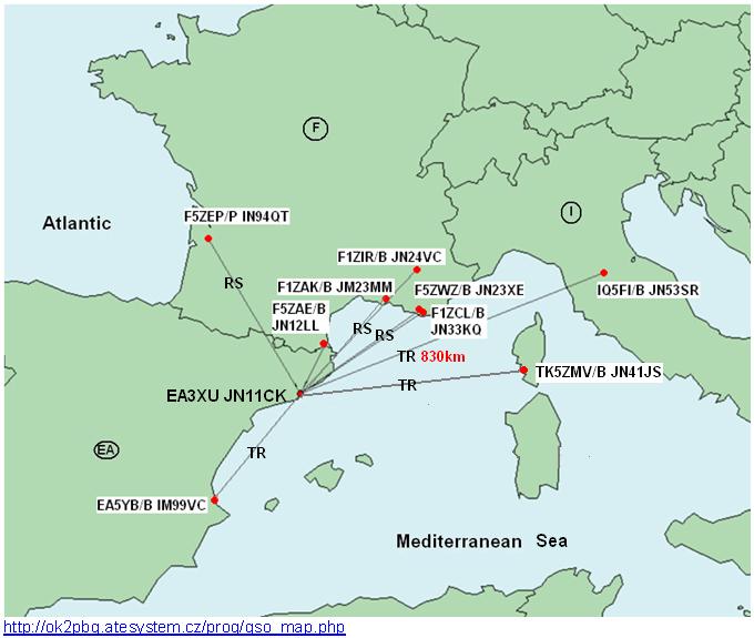
Figure 8. Beacons 10 GHz reception EA3XU
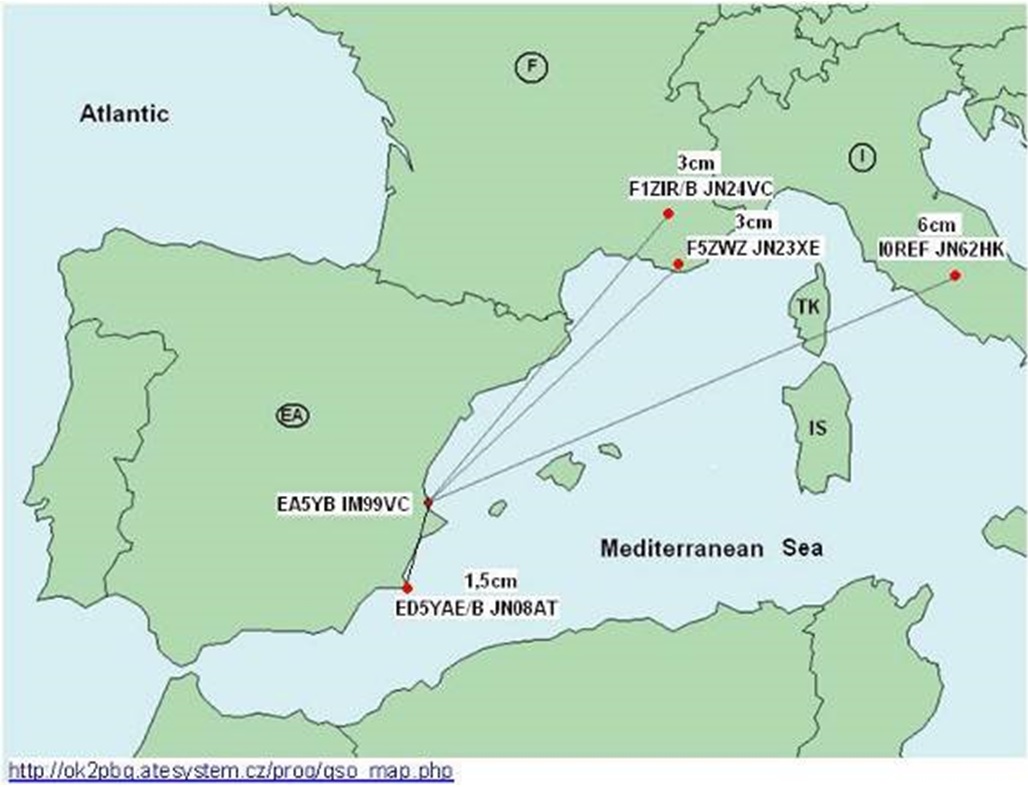
Figure 9. Beacons 10 GHz reception EA5YB
Digital TV (DATV)
Digital Television (DATV): Activity focused on the 70 cm band from 434 to 437 MHz, depending on local noise. Also, in the 23 cm band (1255 MHz). We completed several great two-way QSOs with Filippo (IZ5TEP) from GL:JN53DU. We successfully used several Symbols rates (RS) from 125 to 1500. Also 70/23 cm crossband contact with Liborio (IU2KAC/P). DATV activity map is shown in Figure 10.

Figure 10. DATV Activity map of 23 cm band EA3XU
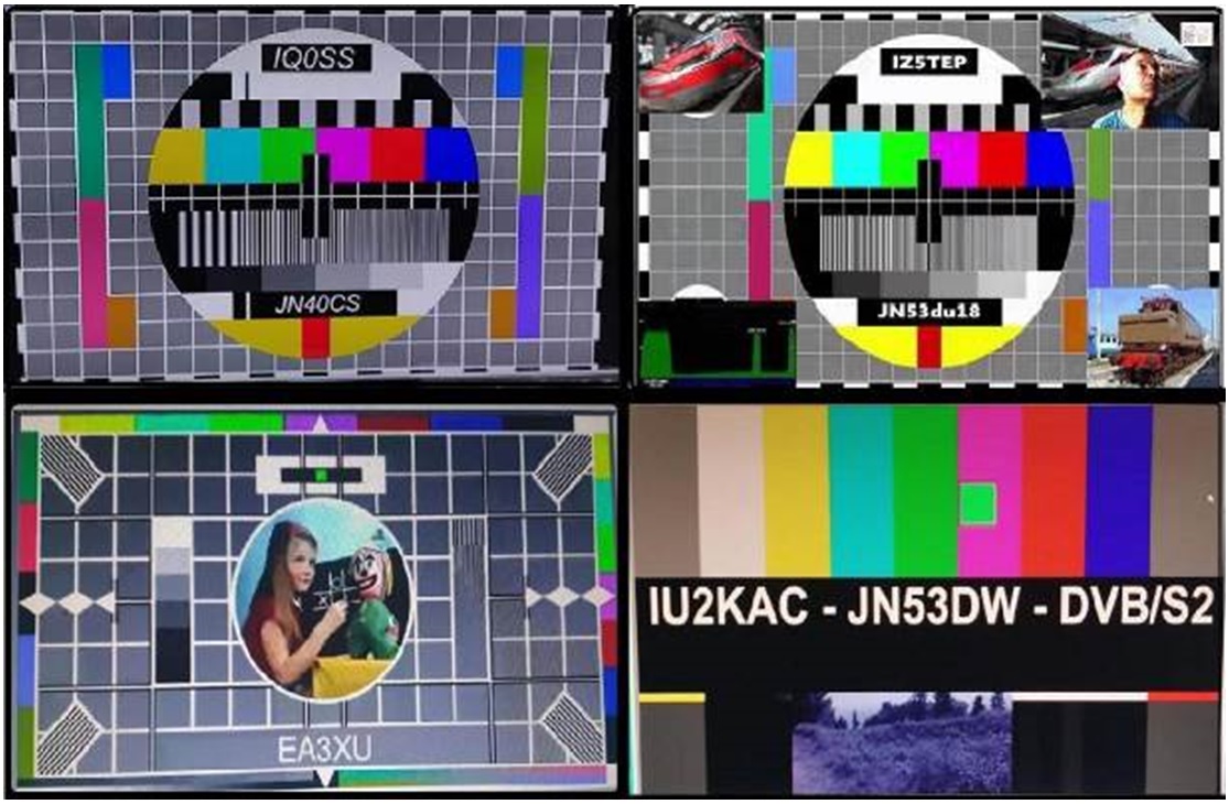
Figure 11. Examples of DATV DXs on 1255 MHz
■ Reference information (Editor's addition)
*1: Catalonia, a region in the northeast of Spain facing the Mediterranean Sea and bordering France.
*2: The eastern part of Spain facing the Mediterranean Sea in the region where Barcelona is located.
GL in the text represents grid locator number.
About the writer:
Benjamin Piñol, EA3XU: https://www.qrz.com/db/EA3XU